
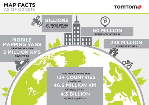
TomTom has announced the addition of navigable maps for thirteen new countries and now provides full navigable coverage for 134 countries.
The company said its global map database now covers over 45.6 million kilometers and 4.3 billion people worldwide.
AMD has launched navigable, turn-by-turn maps for Macedonia, Bosnia & Herzegovina, Peru, Guatemala, Nicaragua, Panama, Costa Rica, Honduras, El Salvador, Iraq, Ghana, Rwanda and Burundi.
In addition, Address Points will enable better geocoding and navigation in Austria, Luxemburg, Turkey and South Africa.
Enhancements also include launch of 3D Map for Singapore and the debut of visualization products for the Middle East, with an Advanced City Model of Riyadh and 2D City Maps for 15 cities.
“The addition of nearly 3 million kilometers of roads in one year demonstrates TomTom’s commitment to geo-expansion,” said Charles Cautley, managing director of TomTom Maps.
Additionally, University of Minnesota’s Accessibility Observatory has deployed TomTom’s (TOM2) map and traffic information as part of a new, national accessibility data set.
The map and historical speed data provided by TomTom will help in analyzing accessibility to jobs for driving and transit for metropolitan areas across the United States.
Company officials said the data can be used for policy development, local transportation system evaluation, performance management, planning and research efforts.
Also, each partner can have direct digital access to the accessibility datasets for the jurisdictions of all partners and will receive detailed reports of local accessibility trends and patterns.
“We are confident that the TomTom map and traffic content will contribute to a better understanding of job accessibility nationwide,” said Ralf-Peter Schäfer, Head of Traffic at TomTom.
Shilpa Khatri